|
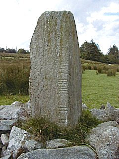
AGHASCREBAGH OGHAM STONE
Map Reference: H618839
The Ogham stone at Aghascrebagh is one of the few such stones in the North of Ireland. It is 145cm high by 45cm by 50cm and
slightly tapering.The inscription down one edge has been interpreted as DOTETTO MAQI MAGLANI but only about six letters can
now be read.
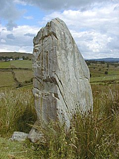
AGHASCREBAGH STANDING STONE
Map Reference: H617840
This schist standing stone is 2.4m high by 1.3m wide and 50cm thick at the base. It tapers slightly.
ALTDRUMMAN PORTAL TOMB
Map Reference: H578768
Altdrumman Dolmen is a tripod structure with good portals and a large backstone. There is only one sidestone. The capstone
is about 1.8m by 2.5m by lm thick. The orthostats are about lm high and the chamber is about 2m by 1m.

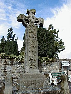
ARDBOE HIGH CROSS
Map Reference: H966756
Ardboe High Cross, in Farsnagh townland is a tall slender object with only one portion of the ring missing. The Cross is a
typical Scripture Cross with many carved panels with figure sculpture. Some panels feature geometrical and other decoration.
Many of the panels are greatly weathered and unclear. A decorated panel encircles the shaft about three-quarters of the way
up. On the west side below the decoration there are four figure panels. The top panel shows the Flight into Egypt, but the
others are not clear. Above the decoration a panel with three figures possibly represents the Arrest of Christ and there is
a Crucifixion at the cross. On the east side the bottom panel shows Adam & Eve. Above this is Abraham & Isaac. At
the cross is the Last Judgement or possibly Christ In Glory. The bottom panel on the south face shows Cain & Abel. The
church nearby is a simple rectangular structure with a north doorway and a pointed east and west window. There are two windows
in the north and south walls. The memorials in the churchyard range from 18th century to modern. One stone of 1759 is topped
by a cross flanked by carved faces. Some stones feature two winged cherubs and one stone has three. The graveyard is still
in use.

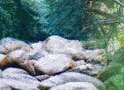
BEAGHMORE STONE CIRCLES
Map Reference: H685843
At Beaghmore there are at least seven stone circles as well as a number of small cairns and collapsed walls. They were revealed
during peat cutting. The function and date of the mounment is not known. There are suggestions that the stones may have been
erected in the late Neolithic or early Bronze Age and may have been used for astronomical observations. A number of the circles
have tangential alignments and one of the circles is filled with small orthostats. One of the cairns is in the middle of an
annular ditch. The stones are generally low but some are over 1m high. To the west are at least two standing-stones and a
small cairn. There are at least two cairns on the other side of the road.

BENBURB CASTLE
Map Reference: H815520
Benburb Castle is built an the edge of a cliff. It is a plantation bawn built in 1611 by Sir Richard Wingfield. It is an irregular
four-sided bawn with the entrance in the north wall. There are large rectangular flanking towers at the north-east and north-west
corners and a smaller round tower at the south-east corner. A 19th century house occupies the SW area of the bawn. The NE
flanker has two fine mullioned and transomed windows in its east wall. The NW flanker has a chimney. The bawn wall is well
provided with musket loops and there is a small gateway in the east wall. If any allure existed it is now removed and the
top of the wall is peaked.

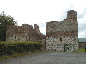
CASTLE CAULFIELD
Map Reference: H755626
There are substantial remains of this large house, built by Sir Toby Caulfield between 1611 and 1619 on the site of an earlier
O'Donnelly castle. The oldest part is the gatehouse which has Tudor-style doorways, murder-holes and gun-loops. The main house
was originally half H in plan but the NW wing is now missing. The building is three storeys high with attics, with many large
mullioned windows and tall chimney stacks. The castle was burned in the rebellion of 1641 but was repaired and reoccupied
by the Caulfields until the 1660s.

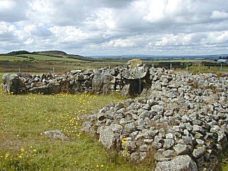
CREGGANCONROE COURT TOMB
Map Reference: H663758
The E forecourt of this tomb has been greatly disturbed and many of its stones are missing. Tall portals, now blocked by a
fallen lintel, lead to a two-chambered burial gallery. The chambers are wide and there is a large displaced capstone. This
suggests that there may have been a lintelled roof instead of the corbelled roof which other court tombs seem to have had.
Near the W end of the cairn are two small burial chambers reached by portals from the long sides of the cairn

CREGGANDEVESKY COURT TOMB
Map Reference: H646751
Creggendevesky Court Tomb was revealed after excavations about 1980. Previous to that time the only visible feature was a
moss-covered lintel on top of a cairn which was almost covered with peat. It was planned to remove this mound as part of a
land improvement scheme. Excavation revealed one of the finest megalithic tombs in Ireland. The tomb has now been fully conserved.
It has a very fine court about 5.6m wide by 5m deep, built with the post and panel technique. One lintel spans the entrance
to the gallery which has three chambers. The grave is set in a large trapezoidal cairn about 16m long by 13m at the front
and 5.5m at the back.
DONAGHMORE HIGH CROSS
Map Reference: H768654
The monastery at Donaghmore was supposedly founded by St Patrick who left Colum in charge. The Bell of Clogher, which is associated
with the monastery, is now in the National Museum, Dublin. The present cross is made up of parts of two crosses. It is richly
decorated with biblical scenes. On the E side the New Testament subjects include the Adoration of the Magi, the Miracle at
Cana and the Crucifixion. On the W side are the Fall of Man, Cain and Abel, and the Sacrifice of Isaac. In the graveyard beside
the cross is a mature hawthorn tree. At the base is a large boulder with a deep bullaun.
DUNNAMORE WEDGE TOMB
Map Reference: H685808
The wedge tomb at Dunnamore is aligned approximately N-S. It is about 11m long by 5m wide. It is damaged and there are some
stones missing so that it is not possible to tell front from back. There are four capstones and good traces of a double wall.
On the west side centre is a short curving projection which may be part of a subsidiary grave.

ERRIGAL KEEROGE CROSS
Map Reference: H585570
This ancient church site has St Ciaran as its patron saint but may have been founded by St Cairthenn, who died in 506. The
most notable structure on the site is a short stone cross about 180cm high with an unpierced ring and stumpy arms. On one
face there is a boss and on the other side there are some incised lines. This may indicate the intention to pierce the ring
and carve some decorative panels. This is a possible unfinished High Cross. Built into the wall of the ruined church is a
replica of an effigy of a male figure.

KNOCKMANY PASSAGE TOMB
Map Reference: H547559
This passage tomb, on the summit of Knockmany Hill, is also known as Annia's Cove. It is the most decorated passage tomb in
the North of Ireland. It has a polygonal chamber with some traces of a passage. Four of the orthostats in the chamber have
decorative motifs, including Concentric circles, lozenges, zigzags and triangles. They are similar to the motifs seen in the
passage tombs in the Boyne Valley and on the Loughcrew Hills. The tomb may date from about 3000 B.C. Knockmany is the best
example of a small collection of such tombs in the Clogher Valley. It is now protected by a modern cover encased in a grassy
mound.

LOUGHMACRORY WEDGE TOMB
Map Reference: H587776
Loughmacrory Wedge-grave is a U-shaped structure about 11m long by 6m wide at the front. It has four capstones each about
2m by 1.5m by 50cm maximum. The ante-chamber is about lm by 1.5m and the burial chamber about 5m by 1.5m. There is a good
double wall and the gap is filled with cairn material.

MOUNTJOY CASTLE
Map Reference: H901687
Mountjoy Castle is a campaign fort built at the beginning of the 17th century. The lower storey is of stone and the upper
storey is of brick. The central rectangular block has four spear-shaped angle towers with gun-loops.
|